|
|

|
  
Features
Update 2020/2/3
Flooding
THE PATH TO FLOOD RESILIENCE: CALGARY, AB
By Gillian Ward
As the days lengthen, and winter snowpack melts into spring 2020, WaterToday looks into the science of hydrology, flood modelling and land use management practises, to learn what Canadian municipalities are doing to mitigate, adapt and manage future floods.
WT interviewed key staff from the City of Calgary to find out how this “dot on the map” situated in a flash flood zone has built out a flood resilience plan since a devastating event in 2013 killed five people and cost more than $5 billion in damages.
Tom Sampson is Chief of Calgary’s Emergency Management organization. According to Sampson, of the 13 risks the City must prepare for, eight are weather related. As for the flood risk, Calgary is uniquely situated at the confluence of two rivers, gravity fed from a high elevation in the mountains. With potentially less than 12 hours notice of impending destructive flows, the work of emergency flood managers here is certainly urgent and critical.
According to Chief Sampson, and as demonstrated on Alberta Environment river flow tool (https://rivers.alberta.ca) the flows coming into Calgary gather melting snowpack and rainfall from ten thousand square kilometres of drainage basin. With no natural lakes to store or slow the water that roars down from Rockies, the Bow and Elbow Rivers at peak flow slam through the City and converge right downtown.

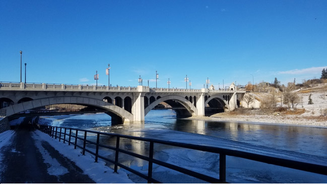
Centre Street Bridge, downtown Calgary. Photo credit Gillian Ward.
Since the flood of 2013, Chief Sampson reports, “Water Services has taken some fairly aggressive steps forward to address the risk of flooding, including things like increasing our resilience level, in some areas where we might have been (prepared for the) one in thirty year flood to a one in two hundred year flood”.
Part of the preparation for future flood events has included building detailed emergency response action plans, of which Calgary has both a Waterworks Emergency Response Manual (WERM) and Flood Emergency Response Manual (FERM). These manuals lay out what each city department will do in the event of an emergency, “where and when, as the water comes”, says Sampson.
Having measured how flow rates impact various parts of the city, the Emergency Management team recognizes where to place the temporary holdback measures. “We are cautious of where we put things up depending on where the flows are going to come, because if you are simply going to wash your sandbags away, then they aren’t a very good tool for that job”, Sampson explains.
“Through our mitigation efforts, I think we have reduced our impact by about 30%, but really, Calgary, because of its unique nature, needs upstream mitigation…we pretty much have to get that at some point in time. We simply can’t deal with the kind of flows that we have seen in both the Bow and Elbow Rivers, we can’t put up sandbags to deal with that, its not the solution, we need long term solutions”, concludes Sampson.
According to Sampson, planning for the next big flood began in the Recovery Operations Centre on Day 2 of the 2013 critical incident. The planning and preparing process has been ongoing for nearly seven years.
Frank Frigo, Hydrological Engineer for the City of Calgary explains the intricate and thoughtful process the City has worked through since 2013, to get to the readiness position Calgary has today.
“What we did recognize right from the outset is… anything we do in terms of water management, whether that’s for flood control, drought control, environmental performance, these things are all interlinked…the last thing we wanted to do was proceed down the path trying to solve one water resources problem, the issue of flooding, and exacerbate or create new problems in other areas in water resources.”
Frigo went on, “Our process was pretty thoughtful..we actually commissioned a panel of experts… they ranged from engineers, to meteorological specialists to architects, right down to citizens; they assisted us with building…the framework that became our flood resilience plan, or road map if you will.”
“A really critical piece along the way was making sure that we were engaging our citizens and stakeholders, both within our municipal jurisdiction and water and environmental stakeholders from outside…there was about two years of engagement that included things like telephone surveys, pop-up events, open houses, technical advisory group, citizens advisory groups…, all that input helped shape our understanding of what peoples’ values were around water.”
“Lots and lots of technical work had to go into this as well…we absolutely wanted to leverage the best science available…that meant new studies, river topography, hydraulic modelling, hydrologic studies to estimate flood flow frequencies… and all kinds of economic studies to project forward and assess if we had either the same hydrologic frequencies as in the past, what would that mean in the future? Or if we had issues like changing climate, what would that mean? “
Frigo explained that flood plans must consider the City of Calgary’s 1.4 million water customers, supplied by treatment plants on both the Bow and Elbow rivers. Calgary had to come up with a combination of solutions, including local and regional, structural/mechanical and non-structural tools.

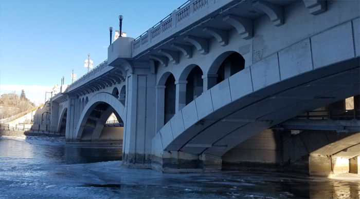
Calgary’s Centre St. Bridge downtown has been retrofitted with structural flood barriers.
Stop-logs are stored out of sight at the bridge for rapid installation. Photo credit Gillian Ward.
“The large complex pieces are not in place yet”, says Frigo, referring to planned infrastructure investments in upstream water storage.
Alberta Community Resilience Programs (ACRP) provincial to municipal funding was hit up for building the plan. The new “Building Canada Fund” has been accessed, with Canada committed to an investment of 168 million dollars. Large projects in the planning stages include the expansion of the Glenmore Reservoir and construction of the Spring Bank Dry Reservoir proposed for the Elbow River, currently in Environmental Review. The increased water storage will bring Calgary to a 60% reduction of the flooding risk.
Dr. Brad Stelfox is an adjunct professor at the Department of Biological Sciences, University of Alberta, and the Department of Environmental Design, University of Calgary. He has designed and developed a modelling tool for land use planning, A Landscape Cumulative Effects Simulator (ALCES), that can be used to estimate flood parameters in a watershed basin, among other features.
According to Dr. Stelfox, management of the forestry and agricultural land is where flood resilience and mitigation begin. “A lot of cities globally, including Canada’s (cities) have ignored this dynamic, and as populations build and as cities grow out…millions become billions, in some cases trillions of dollars of damaged infrastructure on flood plains is now helping Canadians understand that sandbagging is not the answer.”
As previously reported on WaterToday, Canada’s Ministry of Public Safety administers Disaster Financial Assistance Arrangements (DFAA) since 1970, to assist with disasters that go beyond the capacity of the local jurisdiction to manage. According to the annual expenditures records for the DFAA, Canadian taxpayers have shelled out more in disaster relief payments over the last six years than in the four decades prior, combined.
With limited resources for ever increasing damage claims, Canadian Municipalities are called upon to undertake flood risk planning and implement mitigative measures to prevent future flood damage. Many have consulted flood modelling software and subject matter experts as part of the planning process.
For municipalities looking for assistance with flood mitigation plans, the Federation of Canadian Municipalities (FCM) is a key resource. The national organization advocates “for more tools to help municipalities plan for and respond to emergencies, as well as for better collaboration among orders of government to …protect Canadians from health and security risks. We also equip municipalities with key resources to help them meet their public safety responsibilities. All of us want to feel safe and secure in our homes and in our neighbourhoods. Municipalities are leaders and vital partners in ensuring exactly that.”
(Www.fcm.ca).
Dr. Stelfox concludes the discussion on building flood resilient society, “A systems approach dealing with the entire watershed is what is required to mitigate (flood) risk.”
WaterToday will be on hand in Calgary later this spring for the installation of another component of the city’s flood resilience plan, a mechanical/structural flood control system at Heritage Park. Stay tuned for that report along with our next instalment of Canadian Municipalities preparing for flood, as the oldest settled community in the nation, Annapolis Royal, NS plans for rising ocean levels.
gillian@watertoday.ca
|
|
|
Have a question? Give us a call 613-501-0175
All rights reserved 2026 - WATERTODAY - This material may not be reproduced in whole or in part and may not be distributed,
publicly performed, proxy cached or otherwise used, except with express permission.
|
| |